Why a River Keeps Its Bends
Why a river keeps its bends: learn how valley shape, flowing water and sediment shape a winding channel, and recognise the clues along a riverbank.
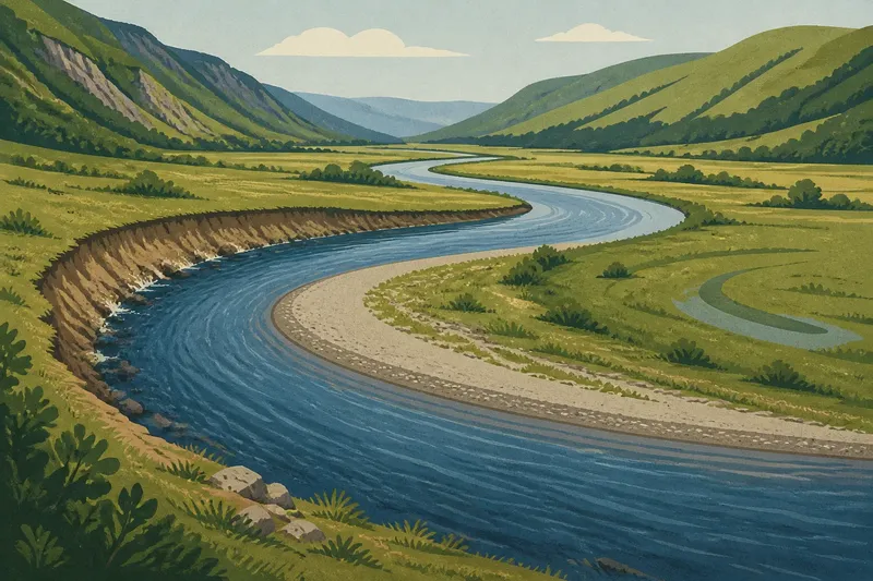
Why a river keeps its bends is easiest to understand from the bank of a curving stream: the outer edge may be steep and exposed, while the inside shore slopes gently towards the water. Those differences reflect how flow and sediment interact with the space the river has to move.
A bend, or meander, is not a detour from a river’s proper course. It is a channel shaped by its surroundings. To make sense of one, look at the valley, the riverbed and banks, and the traces a changing channel may leave behind.
What does the valley let a river do?
A steep, narrow valley leaves a river little room to wander. Slopes, rock and the shape of the valley floor can constrain its route. In a broad, gently sloping valley, the channel has more space to curve across the low ground.
Water moves downhill, but it does not simply take the straightest line towards the sea. A direct route might cross high ground or solid rock. Instead, the river follows a connected path through the landscape, responding to obstacles and available space along the way.
For a practical reading of the valley, consider what you can see from a public path or a safe viewpoint. If the channel winds through a broad strip of low ground, there is room for bends; if slopes or rock closely flank it, its route is more restricted.
How do water and sediment shape a bend?
Flow varies across a channel. Around a curve, water tends to move more strongly along the outer bank and more slowly along the inner bank. The stronger flow can wear away the outside edge, while slower water may leave sand, gravel or finer sediment on the inside.
That contrast can help a bend grow. Erosion shifts the outer bank back, and deposited material can build a shallower shelf called a point bar along the inner bank. Think of a loose ribbon sliding around the rim of a bowl: it follows the shape in front of it rather than pulling itself straight across. A river is more complex, but the comparison makes the role of local shape easier to picture.
From a safe bank, bridge or public path, look for an exposed, steep outer edge and a gentler inner shore with sediment. These clues can be altered by vegetation, rock or built structures, so the two sides will not always look like a textbook example.
Why do some bends shift while others stay in place?
Some bends migrate across a valley floor; others are held in place or move only slightly. Resistant rock, bedrock ledges, dense vegetation and human-made boundaries can limit erosion or guide the channel. Softer banks and open low ground can give a bend more room to change.
Imagine a small river crossing a broad, grassy valley with soft banks. If water wears away the outside of one curve while sediment gathers on its inside, the bend may gradually shift sideways; the expected visible result is a changed channel and perhaps a curved hollow or damp strip left nearby. This is an invented situation, not an observed case.
If neighbouring parts of a bend draw close, water may eventually cut across the narrow neck and take a shorter route. The old curve can then remain as an abandoned channel, sometimes called an oxbow or cut-off meander. The shape of the banks and the river’s setting influence whether that happens.
What should you look for around a river bend?
Use these observations to connect the channel to its surroundings. Each one points to a decision about what to examine next, rather than a firm prediction about what the river will do.
- Check the valley sides. If slopes or rock closely flank the channel, treat the route as constrained and look for bends where the valley opens out; otherwise, examine the low ground beside the river for signs of movement.
- Compare the two banks. If the outer edge is steep and exposed, erosion may be shaping it, so look for sediment on the inside; otherwise, consider whether vegetation, rock or structures hide the contrast.
- Look at the inside shore. If sand or gravel forms a shallow shelf, it may be a point bar, so compare it with the opposite bank; otherwise, check whether water level or dense plants make the deposit hard to see.
- Notice bank materials. If the banks appear soft and exposed, consider whether they could be worn back; if rock or dense roots hold them, look for another part of the bend with fewer constraints.
- Scan the nearby low ground. If a curved hollow or damp strip echoes an older channel, treat it as a possible former course and compare it with the present bend; otherwise, avoid assuming an old channel is visible.
- Check for human-made boundaries. If walls, paths or other structures line a bank, account for their influence before interpreting the channel; if no such boundary is apparent, focus on valley shape, flow and sediment.
How can you read a river bend from the clues?
Why is the outer bank often steeper?
Stronger flow along the outside of a bend can erode the bank and leave a steep edge. The contrast may be less visible where rock or built structures alter the bank.
What is a point bar?
A point bar is sediment deposited along the inside of a bend, where water moves more slowly. It may appear as a shallow shelf of sand or gravel.
Can a river bend without moving?
Yes. Resistant rock, a narrow valley or features along the banks can limit how much a bend shifts. The channel still reflects flowing water, but it has less room to change.
Do all meanders form in broad valleys?
No. Broad valleys often give bends more space, but rivers also curve around obstacles and follow local features. A winding channel does not, by itself, tell you that the surrounding land is a classic floodplain.
Which clues should you consider together?
Say you are looking at an invented river bend from a public footpath. You notice a broad, flat valley floor, a steep exposed outer bank, and a shallow inner shore with gravel. First, the wide floor suggests that the bend has room to shift; next, the opposing bank shapes fit the pattern of erosion outside and deposition inside. You then spot a curved, damp hollow nearby, which could be an older channel trace. The resulting interpretation is that the bend may have migrated, but the hollow alone cannot establish when or why it formed.
Each clue answers a different question: the valley shows how much space is available, the banks and sediment hint at how the curve is being shaped, and the surrounding ground may preserve traces of an earlier route. Taken together, they make why a river keeps its bends clearer without turning a visible pattern into a prediction.
Next time a bend catches your eye, start with the ground beneath and beside it. The useful detail may be a quiet gravel shelf or a strip of low ground, not the curve alone.